The Phase 2 Report Into The Coastal Floods
A reminder from the first report of why our sea defences are important and what could have happened without them:
“The findings of the Phase 1 Report clearly demonstrate the national benefit provided by this network of assets.
- In excess of 24,000 properties could potentially have flooded across the North Wales coast during the December 2013 incident.
- In excess of 50,000 properties around Wales could potentially have flooded across Wales, during the January storms.
If we apply an average buildings insurance flood claim figure of £40,000 to these numbers, it suggests the financial costs of the ‘damages avoided’ in December 2013 and January 2014 are of the order of £960million and £2billion respectively.”
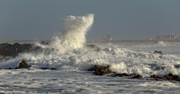
These two storms were both a mark of success of our existing sea defence infrastructure and a wake-up call about the increasing dangers that we face in Wales.
Major recent developments of this infrastructure include:
- Creation of the Flood Forecasting Centre in April 2009. It is fully operational 24 hours a day, 7 days a week.
- Improvements in the quality of the U.K. weather forecast information.
- Improvements in the coverage and quality of flood forecasting and flood warning service.
- Improvements in the understanding of coastal erosion risk and mapping.
- The work of ‘Flood Awareness Wales’ to expand local understanding and community preparedness for flooding.
- Investment in the construction of new coastal defences, such as Borth, Riverside at Newport and Fairbourne.
- Investment in the maintenance and reconstruction of existing coastal defences such as the Tidal Clwyd Embankments.
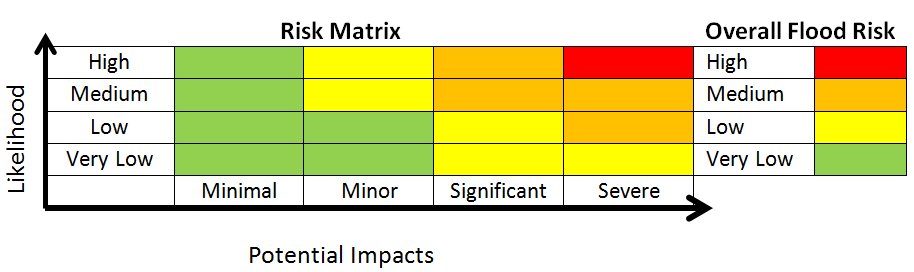
One career route for geographers is in risk forecasting; in 2009 the Flood Forecasting Centre (F.F.C.) was opened to provide flood risk assessments for Wales & England.
Geographers such as those working in the F.F.C. use a risk matrix looking at ‘Likehood’ of an event and ‘Potential Impacts’ of an event to issue colour coded warnings which are then distributed to the public.
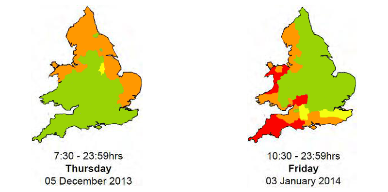
Flood Risk Maps for the two storms in December 2013 and January 2014
This information is then given to National Resources Wales (N.R.W.) which is the organisation in Wales in charge of dealing with flooding as well as all other aspects of the environment in Wales. N.R.W. then works closely with national partners such as the Met. Office (Meteorological Office), Highways Agency & Welsh Government; media partners such as BBC Wales; regional partners such as police forces; local partners such as local councils and communities and even individuals.
The actual Impacts on property are shown on this table, however quite small increases in sea level in several locations would have led to significantly increased impacts.
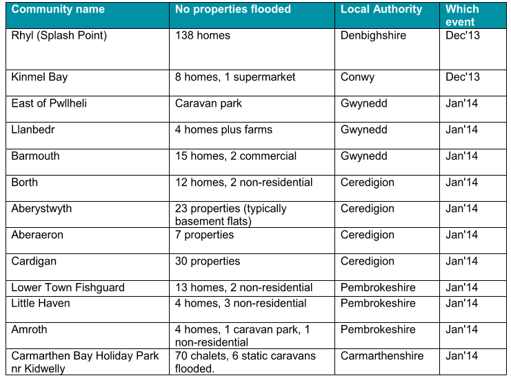
As well as flooding of properties there were further impacts on infrastructure such as railways & roads, evacuations of areas that were a ‘near miss’ and across large areas of agricultural land.
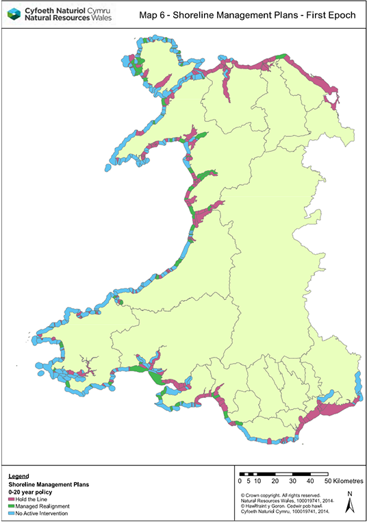
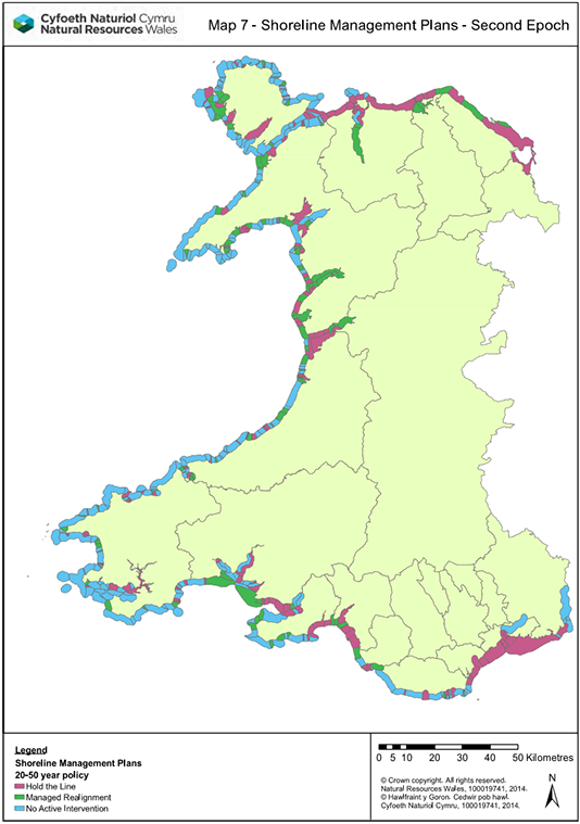
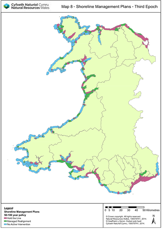
In terms of deciding on how best to manage the coastline the phase 2 report describes the S.M.P.’s or Shoreline Management Plans which are put in place within five Coastal Groups within Wales and with partner groups on adjacent coastlines in England. Strictly speaking we should call each plan an S.M.P.2 as they are now in version two, and you will see them abbreviated to S.M.P2.
In Wales all Decision Making on the Coast is broken down into four Shoreline Management Plans (S.M.P.’s).
- Anchor Head to Lavernock Point; being the ‘Severn Estuary’ S.M.P.
- Lavernock Point to St Ann’s Head; being the ‘South Wales’ S.M.P.
- St Ann’s Head to the Great Orme; being the ‘West of Wales’ S.M.P.
- The Great Orme to the Scottish Border, being the ‘North Wales and North West England’ S.M.P.
Each S.M.P. looks at a 100 year timeframe across 3 epochs for proposed management of our coastline.
These epochs are:
- Epoch 1 (short-term) = years 0 to 20
- Epoch 2 (medium term) = years 20 to 50
- Epoch 3 (long term) = years 50 to 100
One of four policies can be applied per epoch to each coastal management unit (i.e. defined length of coastline) and these policies are:
- No Active Intervention (N.A.I.): where there is no planned investment in coastal defences or operations, regardless of whether or not an artificial defence has existed previously.
- Hold the Line (H.T.L.): an aspiration to build or maintain artificial defences so that the current position of the shoreline remains.
- Managed Realignment (M.R.): by allowing the shoreline to move backwards or forwards naturally, but managing the process to direct it in certain areas.
- Advance the Line (A.T.L.): by building new defences on the seaward side of the original defences.
These are shown on the following maps:
A vital finding of the phase 2 report was that the S.M.P.’s have to be formally endorsed by the Welsh Government so that all future planning in coastal areas can be made within their context.
The Phase 2 Report made 47 recommendations under the following headings which were either agreed or agreed in principle by the Welsh Government.
1-2: Progressing the Recommendations; by compiling a delivery plan.
3-5: Storm Severity; improving our knowledge on the probability of severe storms.
6-9: Flood Forecasting; improving our systems for forecasting floods.
10-17: Flood Warning & Community Response; improve warnings and the ways in which communities use these.
18-26: Operational Response; to review and improve how risk is planned for and responded to.
27-42: Coastal Defences; to review the response of our sea defences to the two storm events and endorse existing S.M.P’s to allow immediate planning to begin.
43-47: Infrastructure Resilience; making sure that important infrastructure such as transport and utilities (electricity, gas, water, phone & internet) are at ‘acceptable’ risk based on these storm events and climate change predictions of increasing frequency (likelihood) of severe events.
As we continue to look at the biggest section of these which are what we do with our coastal defences it is important to remember that improving our knowledge and modelling of severe storms will help with developing flood forecasts, warnings and as a consequence, how our communities and wider agencies of both national and local government respond to these severe events.
In the next linked article you will be asked to look at locations around our coastline and carry out a D.M.E. (Decision Making Exercise) on the coastal defences of specific locations around the coastline of Wales.
Pupil Activity
Use the same categories as the Phase 2 Report to draw a mind map of the ways in which Wales needs to respond to the increasing risks of coastal flooding and erosion in Wales.