KS3: Global citizens; KS2: Monsoon terror
This summer, there has been a lot of flooding in areas of Pakistan. This is a result of this summer’s monsoon rainfall. It has been the worse monsoon in 80 years. The Swat Valley area in Pakistan has been the most seriously affected area.
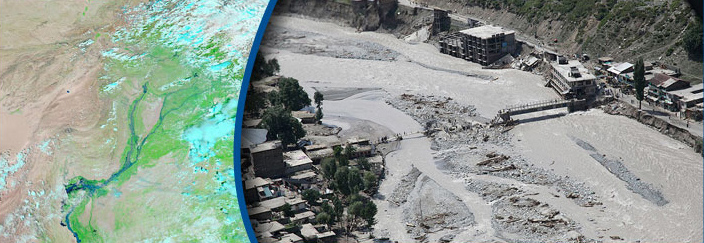
The flooding in Pakistan
Did you know?
We've all heard about Ordnance Survey Maps - but what does 'Ordnance Survey' mean? It's a really odd name for a mapmaking organisation!
The name the organisation comes from its original military purpose. Ordnance is the word used in the army for the section dealing with military supplies. The roots go right back to 1747, when King George II wanted a military map of Scotland to help his troops fight the Scottish clans.
Also, during the Napoleonic Wars in the late 18th and early 19th centuries when there was a threat of invasion from France, it was decided that a complete and accurate map of the whole of the country was needed. This is how the government department called the Ordnance Survey began.
What is a monsoon?
A monsoon is a season of very heavy rainfall. It lasts between June and September. About 65% of the world’s population lives in an area which has a monsoon season. The sub-continents of India and South-East Asia get the most rainfall during this season. They get between 50% to 90% of their annual rainfall.
This year the rainfall and heavy flooding in Pakistan have been so bad that a lot of damage has been caused.
The effects of the floods in Pakistan
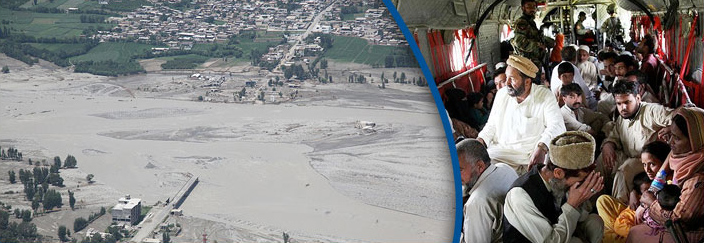
Damage caused by flooding
Homes, roads and bridges have been washed away
Electricity cables have been brought down
Crops have been destroyed
What does this mean?
People have lost their homes
The Prime Minister of Pakistan has estimated that 20 million people have been affected by the country’s floods. The United Nations and many charity organisations are now working hard to help Pakistan cope with the natural disaster.
Did you know?
Ask anybody what 'north' is and the North Pole is sure to be mentioned in the answer. This is known as 'True North' and is the exact top point of the 'axis of rotation' of the spin of the Earth.
Our compasses point to Magnetic North, which is actually a moving point near Ellesmere Island in Northern Canada. It changes its average position North-Northwest (NNW) at an estimated 64 km per year. But what's really strange is that every day it also circles round by up to 80 km.
Most maps have grid lines drawn on them that often point to yet another different 'north'! We call this 'grid north' and it is used to make the map as accurate as possible on a flat surface.