Planning Decisions - The M4 Relief Road
- As a class watch the video clip.
- Why do we plan?
- Who makes plans for your local area?
- What is the NDF?
The Law of Future Generations
All new decisions in Wales need to pass The Law of Future Generations.
- What are the four aspects?
- How many public bodies have to work together in Wales?
- What are the 7 goals?
- Find out the meaning of the following words as they are used in the goals:
- Prosperous
- Resilient
- Cohesive
- Vibrant
- Thriving
- Responsible
- Who/what is the Future Generations Commissioner?
Definition
In the last edition of GitN we started to look at the plans for new section of the M4 motorway around Newport.
This new section would take motorway traffic to the South of Newport.
The arguments about this has been going on since plans to solve the problems started in 1993 - 24 years!
- The M4 is the single most important road in Wales
- Linking South Wales and West Wales to the rest of the UK.
- The Newport section carries more than 100,000 vehicles/day.
- 2/3 of the GDP (money made) of all of Wales comes from land along the M4 motorway in South Wales.
- The M4 around Newport does not meet current safety standards of a motorway.
- Lanes are forced from 8 (three each way plus a hard shoulder) into four (two each way) as they go through two tunnels.
- The cost will be around £1 to £1.2 billion but the benefits to the economy £2.2 to £2.6 billion.
- In rough terms it will make twice as much as it costs for Wales.
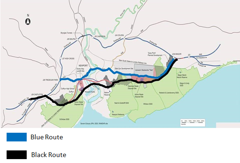
Proposed Route (Black Route)
2016 Information
A. What health issues do the traffic jams cause?
B. How much of the GDP (money earned) in Wales travels along this section of the M4?
C. How many options have been looked into over the years?
D. What % of the SSSI (Sites of Special Scientific Importance) of the Gwent Levels will be affected?
Currently in Spring 2017 there is a public enquiry to look at the black route which the Welsh Government likes the most and other options.
We are going to look at the black route along with the two other main choices which are:
- To do nothing
- A different route called Blue Route
Remember as we look at the choices we have to think about the seven Future Generations goals:
- Prosperous Wales
- Resilient Wales
- Healthier Wales
- More Equal Wales
- Wales of Cohesive Communities
- Wales of vibrant culture and thriving Welsh Language
- Globally Responsible Wales
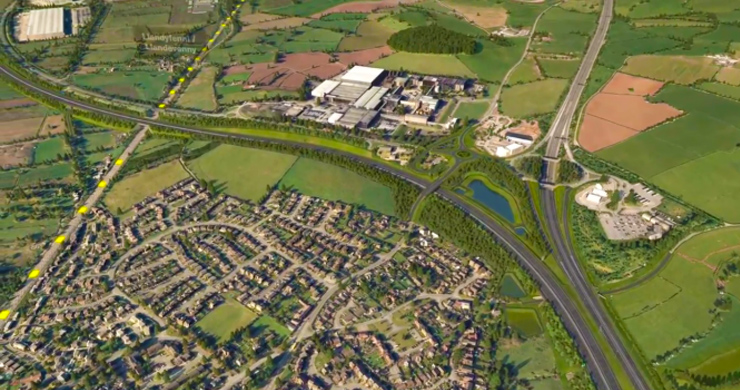
Fly Over Video
This video has been made to show the proposed route (black route). Use this and the map to help you complete the table.
Download Map PDF - Click below

Download OS (detailed) Map PDF - Click below
Student Activity
Use the Fly Over video and the map/s to draw up a table describing what is currently the main land use in the following sections of the proposed road.
Choose from:
- Farmland
- Industry
- Roads
- Water
- Woodland
- Housing
|
From |
To |
North |
South |
|
Junction 23 |
Junction 23A |
|
|
|
Junction 23A |
Gwent Europark |
|
|
|
Gwent Europark |
Solutia Chemical Works |
|
|
|
Solutia Chemical Works |
River Usk/Newport Docks |
|
|
|
River Usk/Newport Docks |
Castleton |
|
|
After reading all three articles and doing the activities, use the linked A3 sheet to work on a DME into the M4 Relief Road.
Teacher Box
The resource is designed to be used as whole class resource from the front of the classroom on the projector/interactive whiteboard.
The various graphics should be supported by teacher exposition based on the text which will not be readable in permitted time to the vast majority of pupils), following this it is ideal that the students have access to the online resource in order to work on the activity sheet (designed to be printed on A3 size paper).
Ideally these activities will be supported by the use of a network room, tablets/laptops or students own phones/devices if permitted.
However the activities are also designed to be used in a typical one hour lesson with the teacher input using the resource from the front of the classroom alongside the resource sheet.
Students can then be set a homework task to study the three articles in advance of the following lesson.
The resource and accompanying sheet is designed to support the LNF framework while giving students key geographical knowledge about places in relation to the proposed M4 Relief Road.
Pupil Box
Either in class or at home read and complete the activities in the online resource article and in the linked articles in this edition of Geography in the News. Attempt to complete all of the activities in the resource sheet.
What you will learn:
- You will increase your knowledge about the infrastructure the proposed M4 Relief Road
- You will increase your understanding of how these factors may affect human beings and human activities
- You will have you the opportunity to learn or practice important literacy and numeracy skills.
You will learn new geographical terms highlighted in purple these should be learned and added to a glossary. A glossary is a list of words and their meanings. You could have one in the back of your geography exercise book, if you have a planner it is probably a good place to keep a glossary, or you may keep a separate glossary or word book. A good glossary helps you build your vocabulary and your literacy. Research meanings using related article content, discussion or a dictionary (either online or a book).