Investigating different Types of Plate Boundaries and Hazards
© British Broadcasting Corporation (BBC)
© British Broadcasting Corporation (BBC)
Student Activity
- Work as part of a pair.
- Watch the two BBC News Clips.
- Quickly note down the different types of dangers that you see.
- As a pair agree a rank order for the dangers.
In the last edition of GITN we looked in detail at different plate boundaries and earthquakes. Refresh your memory with this diagram from the last edition or go back and read it again.
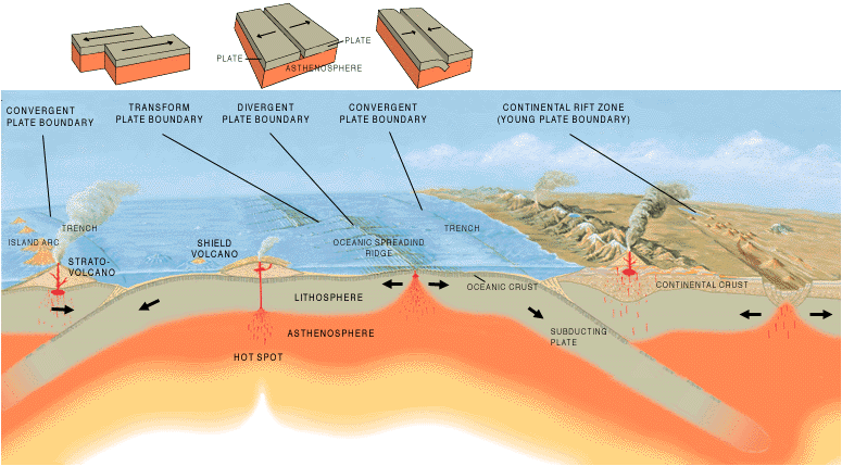
Image: Tectonic plate boundaries - Jose F. Vigil. USGS © Public Domain
Last time we looked at earthquakes; this time we are going to look at volcanoes.
Remember the top layers of the earth are made up of solid plates that move around. Most earthquakes and volcanoes are found where they meet or to use the correct terms the margins of plates or plate boundaries.
Divergent Boundary
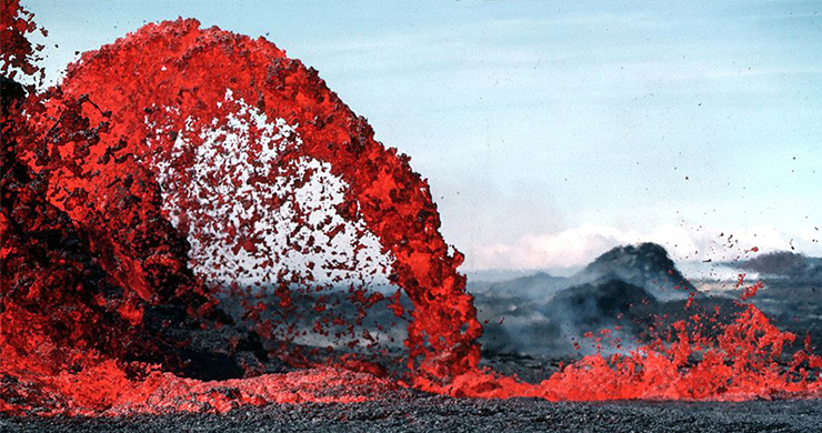
When two plates move apart there will be a lot of volcanoes.
Refresh your memory with this diagram from the last edition.
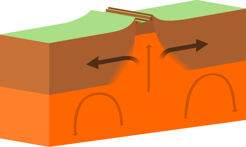
Image: Continental-continental constructive plate boundary - domdomegg © Wikimedia Commons under Creative Commons Attribution-Share Alike 4.0 International
The type of magma (melted rocks beneath the surface) that is created at Divergent boundaries is normally very fluid (runny like a liquid).
When it reaches the surface magma becomes lava it can easily flow a long way.
As a result it creates wide volcanoes with gentle slopes which look like a warriors shield from Anglo Saxon or Viking times.
These volcanoes are therefore called shield volcanoes.
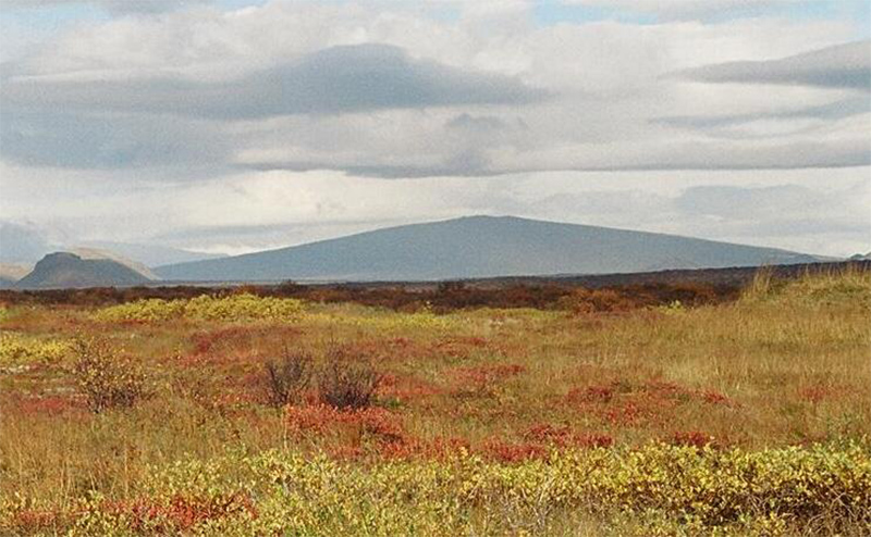
Image: Skjaldbreidur Herbst 2004 - Reykholt © Wikimedia Commons under Creative Commons Attribution-Share Alike 3.0 Unported
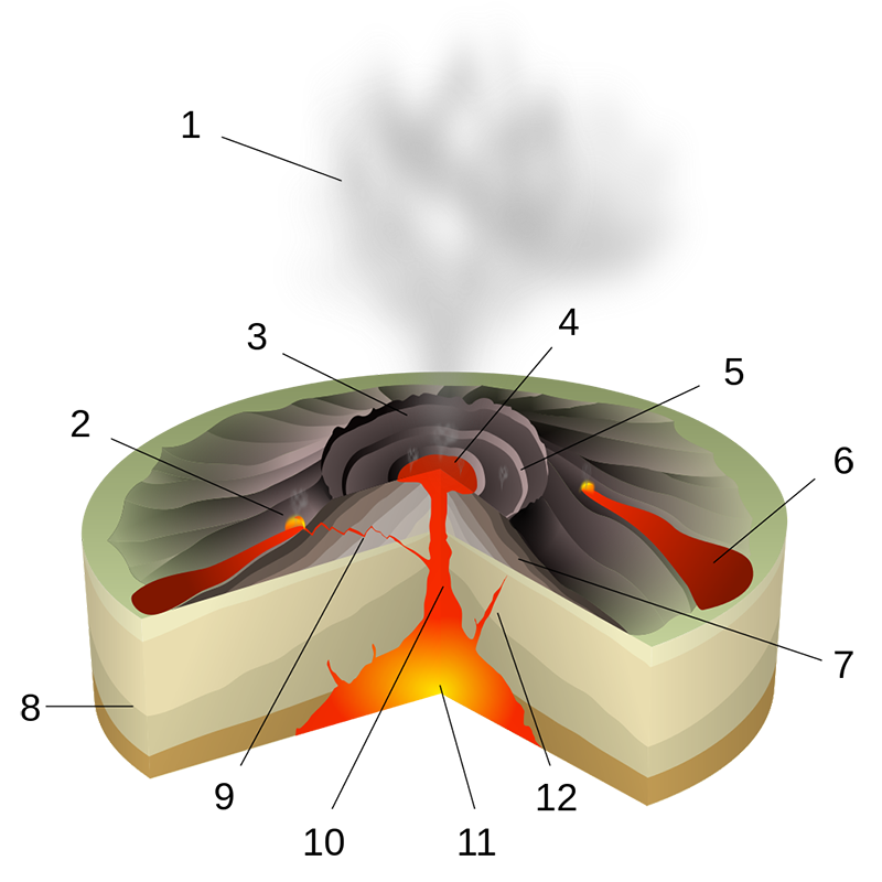
- Ash Cloud
- Lava fountain
- CRATER
- Lava lake
- Fumaroles
- LAVA FLOW
- LAYERS OF ASH & LAVA
- Stratum/layer
- Sill
- Magma conduit
- MAGMA CHAMBER
- Dike
Image: Hawaiian Eruption-numbers - Sémhur © Wikimedia Commons
We will look at some of these in more detail later.
Convergent Boundary
When plates are forced together melting can happen if one plate is forced downwards (subduction).
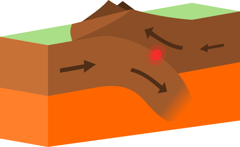
Image: Continental-continental destructive plate boundary - domdomegg © Wikimedia Commons under Creative Commons Attribution-Share Alike 4.0 International
At these plate boundaries magma is very thick and viscous.
Viscous magma cannot flow easily so will make steep sided cone shaped volcanoes.
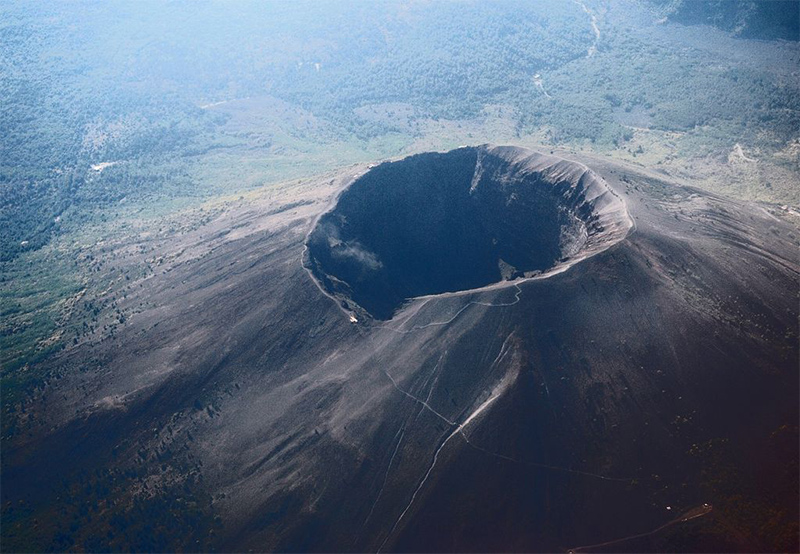
Image: Vesuvius from plane - Pastorius © Wikimedia Commons under Creative Commons Attribution-Share Alike 3.0 Unported
Another feature of thick viscous magma/lava is that dissolved gasses within it cannot escape easily.
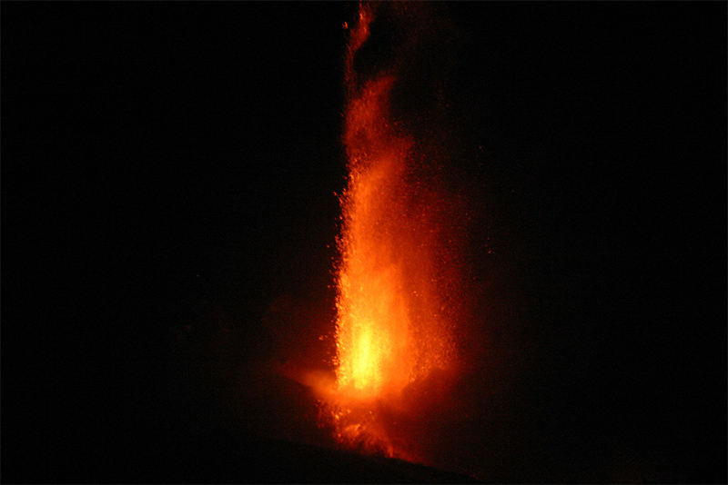
Image: 04Sep2007 Etna from SE Crater - Jason Bott, Christopher Berger, Pete Garza © Wikimedia Commons under Creative Commons Attribution-Share Alike 3.0 Unported
- The gasses dissolved in magma/lava are similar to the dissolved gasses in a bottle of fizzy pop.
- When a bottle of pop is opened you can see the gas as small bubbles.
- This is what happens with the runny magma/lava found at divergent boundaries.
- When thick, viscous magma reaches the surface the gas causes an explosion (a bit like shaking a bottle of fizzy pop).
- This explosion blasts overlying rock and magma in to the air as volcanic ash and volcanic bombs.
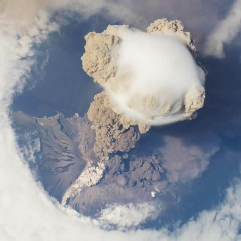
Image: Sarychev Peak eruption on 12 June 2009, oblique satellite view - ISS Crew Earth Observations experiment and Image Science & Analysis Laboratory, Johnson Space Center / NASA © Public Domain
This is why volcanoes at these margins are made up of thick layers of ash and layers of lava. These are often called composite cone volcanoes.
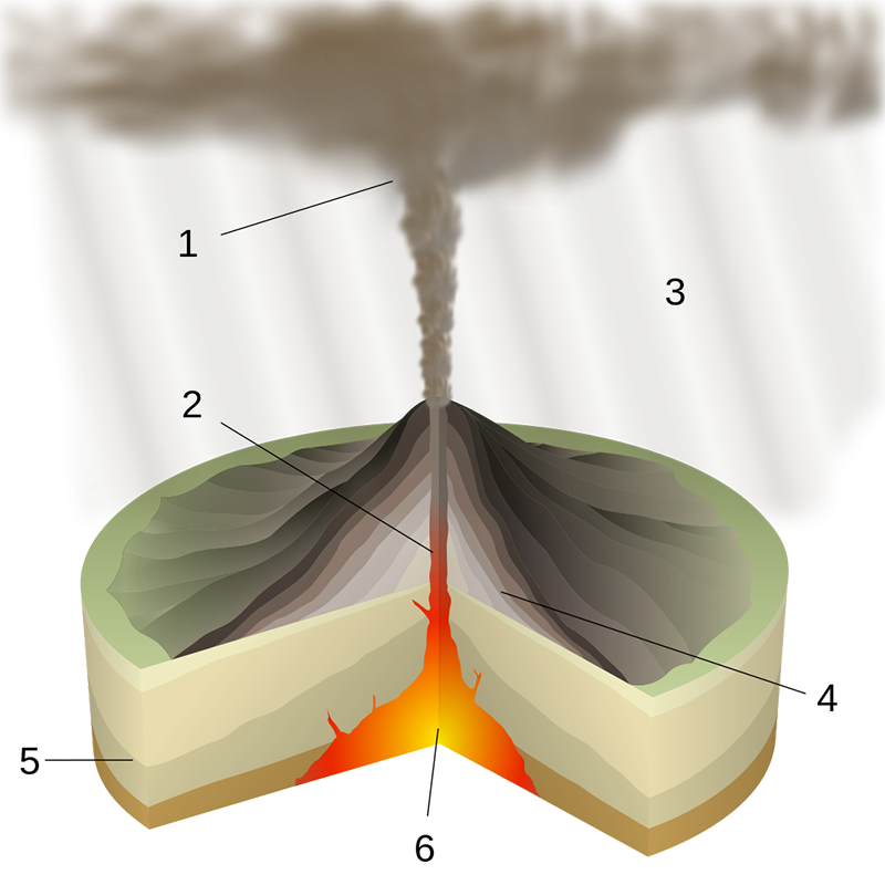
- Ash plume
- Magma conduit
- Volcanic ash fall
- Layers of lava and ash
- Stratum
- Magma chamber
Image: Plinian Eruption-numbers - Sémhur © Wikimedia Commons
These are the two main types of volcanic eruption that geography students are expected to know.
Sometimes a volcano can be found away from the edges of plates where a hotspot occurs in the Earth’s mantle.
We are not sure what causes these hotspots but we do know that as the overlying plate moves over the hotspot a volcano is formed.
The most well know hotspot is where the Islands of Hawaii have been formed as the pacific plate moves over a hotspot.
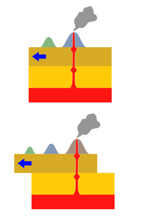
Image: Hotspot(geology)-1 - Los688 © Public Domain
By looking beneath the surface of the Pacific Ocean we can see a long line of old volcanoes called sea mounts rising up from the ocean floor.
These are the old volcanic islands that used to be above the hotspot.
Magma formed at a hotspot tends to be fluid similar to magma formed at divergent boundaries so shield volcanoes are also formed here.
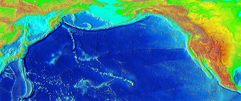
Image: Hawaii hotspot - National Geophysical Data Center / USGS © Public Domain
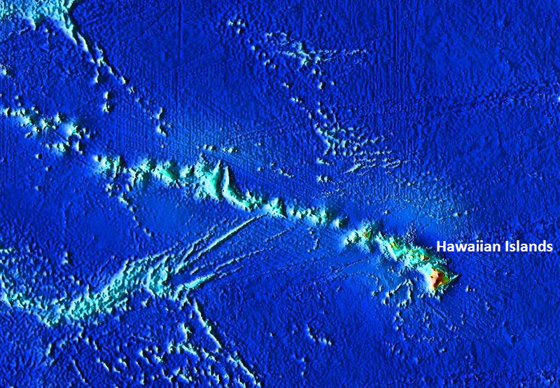
Image: Hawaiian seamount chain - Interiot~commonswiki © Public Domain
Student Activity
Draw a table to help you to describe similarities and differences between shield and composite cone volcanoes.
|
Similarities |
Differences |
|
|
|
|
|
|
|
|
|
|
|
|
|
|
|
After reading all three articles and carrying out the activities. Use the accompanying A3 sheet to help you to complete a DME into tectonic hazards.
Teacher Box
The resource is designed to be used as whole class resource from the front of the classroom on the projector/interactive whiteboard.
The various graphics should be supported by teacher exposition based on the text which will not be readable in permitted time to the vast majority of pupils), following this it is ideal that the students have access to the online resource in order to work on the activity sheet (designed to be printed on A3 size paper).
Ideally these activities will be supported by the use of a network room, tablets/laptops or students own phones/devices if permitted.
However the activities are also designed to be used in a typical one hour lesson with the teacher input using the resource from the front of the classroom alongside the resource sheet.
Students can then be set a homework task to study the three articles in advance of the following lesson.
The resource and accompanying sheet is designed to support the LNF framework while giving students key geographical knowledge about places in relation to Tectonic hazards.
Pupil Box
Either in class or at home read and complete the activities in the online resource article and in the linked articles in this edition of Geography in the News. Attempt to complete all of the activities in the resource sheet.
What you will learn:
- You will increase your knowledge about the Tectonic hazards
- You will increase your understanding of how these factors may affect human beings and human activities
- You will have you the opportunity to learn or practice important literacy and numeracy skills.
You will learn new geographical terms highlighted in purple these should be learned and added to a glossary. A glossary is a list of words and their meanings. You could have one in the back of your geography exercise book, if you have a planner it is probably a good place to keep a glossary, or you may keep a separate glossary or word book. A good glossary helps you build your vocabulary and your literacy. Research meanings using related article content, discussion or a dictionary (either online or a book).