Investigating Increased Coastal Flood Risk in Wales
With partners, write headlines to go with this photograph; write headlines from the points of view of:
A Bus Passenger
A Villager
The Welsh Government
The Increasing Risk Of Coastal Flooding In Wales
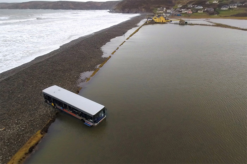
In December 2013 and January 2014 there were many incidents of coastal flooding due to large storms around Wales. Some parts of Wales were to be hit again in February as is shown in this photograph from Newgale In Pembrokeshire.
Related links
Around Wales
December 2013 brought storms and flooding to North Wales this was followed in January 2014 by storms that caused widespread damage around the coastline of Wales; there was destruction of the sea front in Aberystwyth and similar scenes were seen in Porthcawl with roads being closed due to towering waves and the collapse of protective walls.
Welsh Government Action
Immediately the Welsh Government ordered two reports into the events. We are going to investigate the first report into what happened in this edition of Geography In The News, and look more at the second report into what can be done in the future in the next edition.
The first report tells us why our coastlines are so important in Wales:
- 60% (1.9million) of the population of Wales live on, or near to the coast.
- The coastal and marine environment supports an estimated 93,000 jobs, with visits to the coast accounting for over 40% of overnight stays in Wales.
- An estimated 415km of man-made sea defence structures exist to protect over £8billion of assets from coastal erosion and tidal flooding.
- Replacing these structures would cost about £750million.
What Did we Learn?
Storm Severity
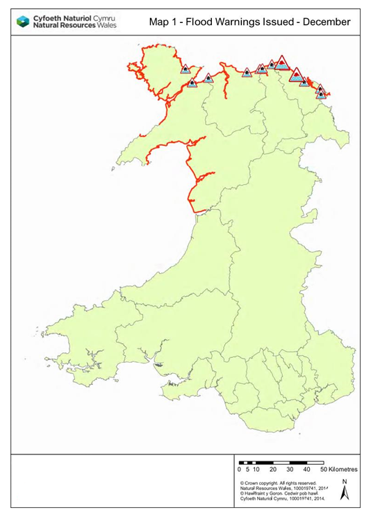
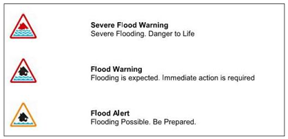
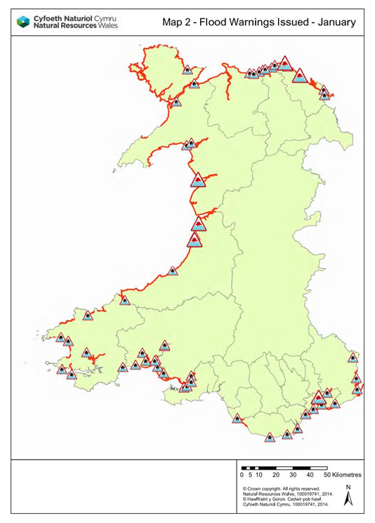
In December 2013 a storm with severe gale force winds hit North Wales. These created high sea levels and large onshore waves that coincided with high tide. This map from the report shows the locations of flood warnings and alerts along the North Wales coastline.
During January 2014 there was a series of storm systems which arrived from the Atlantic Ocean. These storms caused high sea levelsand very large waves. These combined with high tides caused considerable disruption to the south and west coasts.
This serious event lasted from the first high tide on the 3rd of January through to the 6th of January. Each storm system brought more gale force winds and very large waves.
The impacts of the December 2013 storm were confined to North Wales. Around 155 properties experienced internal flooding, mainly in Rhyl with 136 properties and Kinmel Bay with 8 properties. A further 400 properties were advised to evacuate, and over 200 people were received at rest centres in Rhyl such as leisure centres.
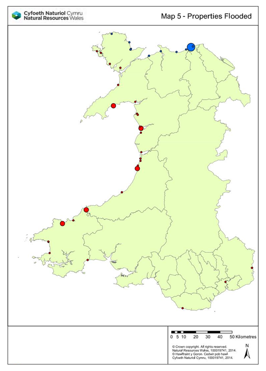
The impacts of the January 2014 storm were much more widespread around the west and southern coastline of Wales, with approximately 100 communities affected from Anglesey through to Monmouthshire.
Approximately 150 properties were reported to have internal flooding, including 21 in Cardigan, 12 in Aberystwyth, 15 in Barmouth and 13 in Fishguard in Pembrokeshire.
In Ceredigion over 600 properties were advised to evacuate in Borth, Aberystwyth and Cardigan; in Newport 450 properties were advised to evacuate.
|
Properties Flooded |
|
|
Cardigan |
21 |
|
Aberystwyth |
12 |
|
Barmouth |
15 |
|
Fishguard |
13 |
The two most notable locations where sea defences were overwhelmed were:
- Rhyl in December 2013.
- Llanbedr in January 2014.
Damage to Sea Defences
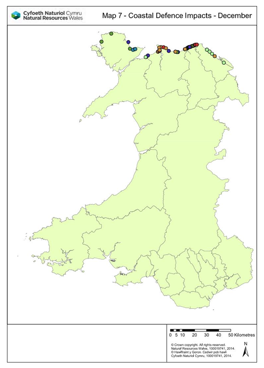
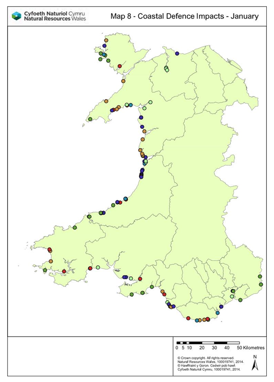
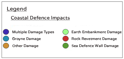
Wales was lucky in that the January set of storms did not hit the same section of coastline as the December storms. This is because there was a large amount of damage to the sea defences by both events and two direct hits at high tide would probably have caused much greater impacts.
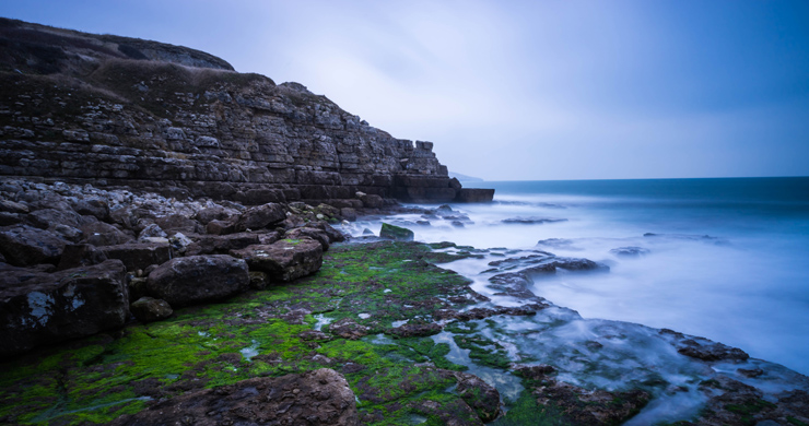
The report also points out that in addition to flood risk; the Welsh coast is also exposed to erosion risks. The coastal areas are affected by powerful forces and are constantly changing; even sections of the coastline made up of hard solid rock are undergoing erosion. Some of this erosion happens slowly, but some can happen rapidly, such as a rock fall that happened at Porthkerry Leisure Park near Barry.
What do you think it means when we read that the 415 km of man-made sea defences in Wales protect over £8 billion in assets?
A billion is one thousand million; an asset is something with a value.
Why do you think we might be considered to have been lucky following the January storms?
Think about the scale of the damage to existing sea defences and what might have happened if the February event had been a ‘direct hit’ at high tide.
Student Activity
Investigation
First try to read the rest of the linked resources and use the student resource sheet to help you carry out an investigation into the coastal flood risks exposed by the storms of late 2013 and early 2014. Use it to formulate questions which you can follow up after the edition of Geography In The News.
Introduction
- In this section you will explain what it is that you are investigating.
- You will choose questions for enquiry that you want to answer.
- You will explain important background information.
- Outline a plan of what you intend to do and what data you will collect or use. You do not need to visit the coastline but you could ask questions in a questionnaire about what people remember about the storms or if they have visited a location. You can also use GIS (Geographical Information Systems) to gather information; a good GIS is Google maps especially with the ‘zoomable’ satellite views, aerial photographs and in some places even street views of locations.
Results
- Use maps from the articles
- Use photographs from GIS
- Tabulate (put in tables) data.
- Convert the data into easier forms to interpret:
- Use graphs.
- Simplify data into things like rounded numbers or a representative mean.
Analysis
- Show how your results answer your questions for enquiry:
- Annotate graphs, photographs, maps and diagrams.
- Construct paragraphs.
Conclusions
- For each of your enquiry questions what have you found out? What is the answer?
Methodology
- Often the Methodology follows the Introduction as you explain what you plan to do. In this investigation we are going to place the Methodology before the Evaluation so that we can better develop our evaluative skills for the future.
- You will explain how you gathered your data and justify your choices.
- You will explain how you represented your data and justify your choices.
Evaluation
- Evaluate your process (how you carried out your investigations (methods)) – what was successful? What went wrong? What could you do differently next time?
- Evaluate your sources – (your information and data) which are reliable and why? Which might be biased and why?
- Evaluate your outcomes – (your conclusions) what is reliable and why? Which may be wrong or inaccurate and why?
- Formulate more questions for a future enquiry based on your findings; this is especially important to find out for your decision making on coastlines in the next edition.